

Resolutions#
resolution is the HEALPix order, and it is the only grid parameter there is. Polypix accepts 0 through 29. When you are allocating or checking a dense map,
polypix.cell_count(resolution) gives you the length.
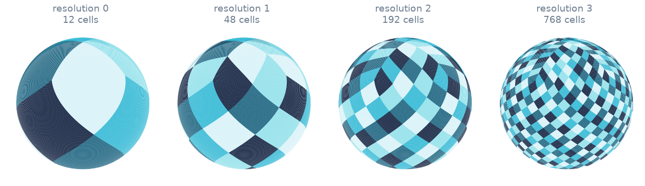
Every resolution starts from the same 12 cells and splits each one into four. Cells are equal in area at every level, which is what makes the grid useful for counting, and why they change shape between the poles and the equator.#
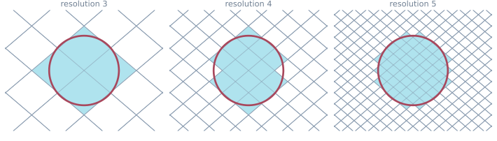
The same region on three grids. Each step up quadruples the cell count and roughly halves the cell size.#
Reading the table#
Every cell on the sphere covers exactly the same solid angle, but their shapes
differ: a cell near a pole is not shaped like one on the equator, so no single
edge length holds everywhere. The nominal cell size below is sqrt(cell area),
which is the usual stand-in and matches what healpy.nside2resol() reports.
Treat it as a typical size rather than as a bound on how wide any particular cell
gets.
The Earth column is that same angle laid on a sphere of radius 6,371 km, the IUGG mean radius, so it is roughly the distance across a typical cell at ground level.
Resolution |
|
Cells |
Nominal cell size |
On Earth |
Dense |
|---|---|---|---|---|---|
0 |
1 |
12 |
58.63° |
6,520 km |
96 B |
1 |
2 |
48 |
29.32° |
3,260 km |
384 B |
2 |
4 |
192 |
14.66° |
1,630 km |
1.5 KiB |
3 |
8 |
768 |
7.329° |
815 km |
6 KiB |
4 |
16 |
3,072 |
3.665° |
407.5 km |
24 KiB |
5 |
32 |
12,288 |
1.832° |
203.7 km |
96 KiB |
6 |
64 |
49,152 |
54.97′ |
101.9 km |
384 KiB |
7 |
128 |
196,608 |
27.48′ |
50.93 km |
1.5 MiB |
8 |
256 |
786,432 |
13.74′ |
25.47 km |
6 MiB |
9 |
512 |
3,145,728 |
6.871′ |
12.73 km |
24 MiB |
10 |
1,024 |
12,582,912 |
3.435′ |
6.367 km |
96 MiB |
11 |
2,048 |
50,331,648 |
1.718′ |
3.183 km |
384 MiB |
12 |
4,096 |
201,326,592 |
51.53″ |
1.592 km |
1.5 GiB |
13 |
8,192 |
805,306,368 |
25.77″ |
795.9 m |
6 GiB |
14 |
16,384 |
3,221,225,472 |
12.88″ |
397.9 m |
24 GiB |
15 |
32,768 |
12,884,901,888 |
6.442″ |
199 m |
96 GiB |
16 |
65,536 |
51,539,607,552 |
3.221″ |
99.48 m |
384 GiB |
17 |
131,072 |
206,158,430,208 |
1.61″ |
49.74 m |
1.5 TiB |
18 |
262,144 |
824,633,720,832 |
805.2 mas |
24.87 m |
6 TiB |
19 |
524,288 |
3,298,534,883,328 |
402.6 mas |
12.44 m |
24 TiB |
20 |
1,048,576 |
13,194,139,533,312 |
201.3 mas |
6.218 m |
96 TiB |
21 |
2,097,152 |
52,776,558,133,248 |
100.6 mas |
3.109 m |
384 TiB |
22 |
4,194,304 |
211,106,232,532,992 |
50.32 mas |
1.554 m |
1.5 PiB |
23 |
8,388,608 |
844,424,930,131,968 |
25.16 mas |
777.2 mm |
6 PiB |
24 |
16,777,216 |
3,377,699,720,527,872 |
12.58 mas |
388.6 mm |
24 PiB |
25 |
33,554,432 |
13,510,798,882,111,488 |
6.291 mas |
194.3 mm |
96 PiB |
26 |
67,108,864 |
54,043,195,528,445,952 |
3.145 mas |
97.15 mm |
384 PiB |
27 |
134,217,728 |
216,172,782,113,783,808 |
1.573 mas |
48.57 mm |
1.5 EiB |
28 |
268,435,456 |
864,691,128,455,135,232 |
786.3 µas |
24.29 mm |
6 EiB |
29 |
536,870,912 |
3,458,764,513,820,540,928 |
393.2 µas |
12.14 mm |
24 EiB |
Picking one#
Match the grid to the smallest feature you care about.
Some rough anchors:
Resolutions 6 and 7, around 100 km and 50 km, suit constellation coverage and revisit studies. The case studies use 6 for communications and 7 for Earth observation.
Resolutions 8 to 10, from 25 km down to 6 km, suit regional analysis and most sensor-footprint work.
Resolution 12, around 1.6 km, is about where a dense global map stops being comfortable, since one
int64per cell is already 1.5 GiB.Above 13, dense global arrays are out of the question. The high resolutions are there for sparse work: pass
candidate_cells=to restrict coverage to the cells you care about, or toCoverage.reduce()to query a short list. See Performance and memory.